
About
This plot is a choropleth map. It show the CO2 emissions per capita in 2021 for each country.
The chart was made by Joseph Barbier. Thanks to him for accepting sharing his work here!
Let's see what the final picture will look like:
Libraries
First, you need to install the following librairies:
- matplotlib is used for creating the chart and add customization features
- pandas and
geopandasare used to put the data into a dataframe and manipulate geographical data - drawarrow for the arrows
- pyfonts for the fonts
geopandas: for the geographical datahighlight_text: to add beautiful annotations to the chart
And that's it!
import pandas as pd
import geopandas as gpd
import matplotlib.pyplot as plt
from pypalettes import load_cmap
from drawarrow import fig_arrow
from pyfonts import load_google_font

from highlight_text import fig_text, ax_text
Dataset
Creating a choropleth map necessitates a dataset with geographical information. For this example, we need to load the world map from the Gallery's repo.
Next, we should load the dataset containing the values we want to represent on the map, such as CO2 per capita by country. This dataset is also accessible in the Gallery's repo.
url = "https://raw.githubusercontent.com/holtzy/the-python-graph-gallery/master/static/data/europe.geojson"
world = gpd.read_file(url)
world.head()| pop_est | continent | name | iso_a3 | gdp_md_est | geometry | |
|---|---|---|---|---|---|---|
| 0 | 144373535.0 | Europe | Russia | RUS | 1699876 | MULTIPOLYGON (((180 71.51571, 180 70.8322, 178... |
| 1 | 5347896.0 | Europe | Norway | NOR | 403336 | MULTIPOLYGON (((15.14282 79.67431, 15.52255 80... |
| 2 | 67059887.0 | Europe | France | FRA | 2715518 | MULTIPOLYGON (((-51.6578 4.15623, -52.24934 3.... |
| 3 | 10285453.0 | Europe | Sweden | SWE | 530883 | POLYGON ((11.02737 58.85615, 11.46827 59.43239... |
| 4 | 9466856.0 | Europe | Belarus | BLR | 63080 | POLYGON ((28.17671 56.16913, 29.22951 55.91834... |
Now we merge this dataset with the world map with a merge function. This function will match the country names in the two datasets and add the CO2 values to the world map dataframe.
url = "https://raw.githubusercontent.com/holtzy/the-python-graph-gallery/master/static/data/co2PerCapita.csv"
df = pd.read_csv(url)

# merge data
data = world.merge(df, how="left", left_on="name", right_on="Country")

# filter to keep only specific countries
data = data[data["continent"] == "Europe"]
data = data[~data["name"].isin(["Russia", "Iceland"])]
data = data[data["Year"] == 2021]
data = data[["name", "Total", "geometry"]]
data = data.dropna()
data.head()| name | Total | geometry | |
|---|---|---|---|
| 543 | Norway | 7.573273 | MULTIPOLYGON (((15.14282 79.67431, 15.52255 80... |
| 815 | France | 4.741312 | MULTIPOLYGON (((-51.6578 4.15623, -52.24934 3.... |
| 1087 | Sweden | 3.424918 | POLYGON ((11.02737 58.85615, 11.46827 59.43239... |
| 1359 | Belarus | 6.222741 | POLYGON ((28.17671 56.16913, 29.22951 55.91834... |
| 1631 | Ukraine | 4.637058 | POLYGON ((32.15944 52.06125, 32.41206 52.28869... |
Background map
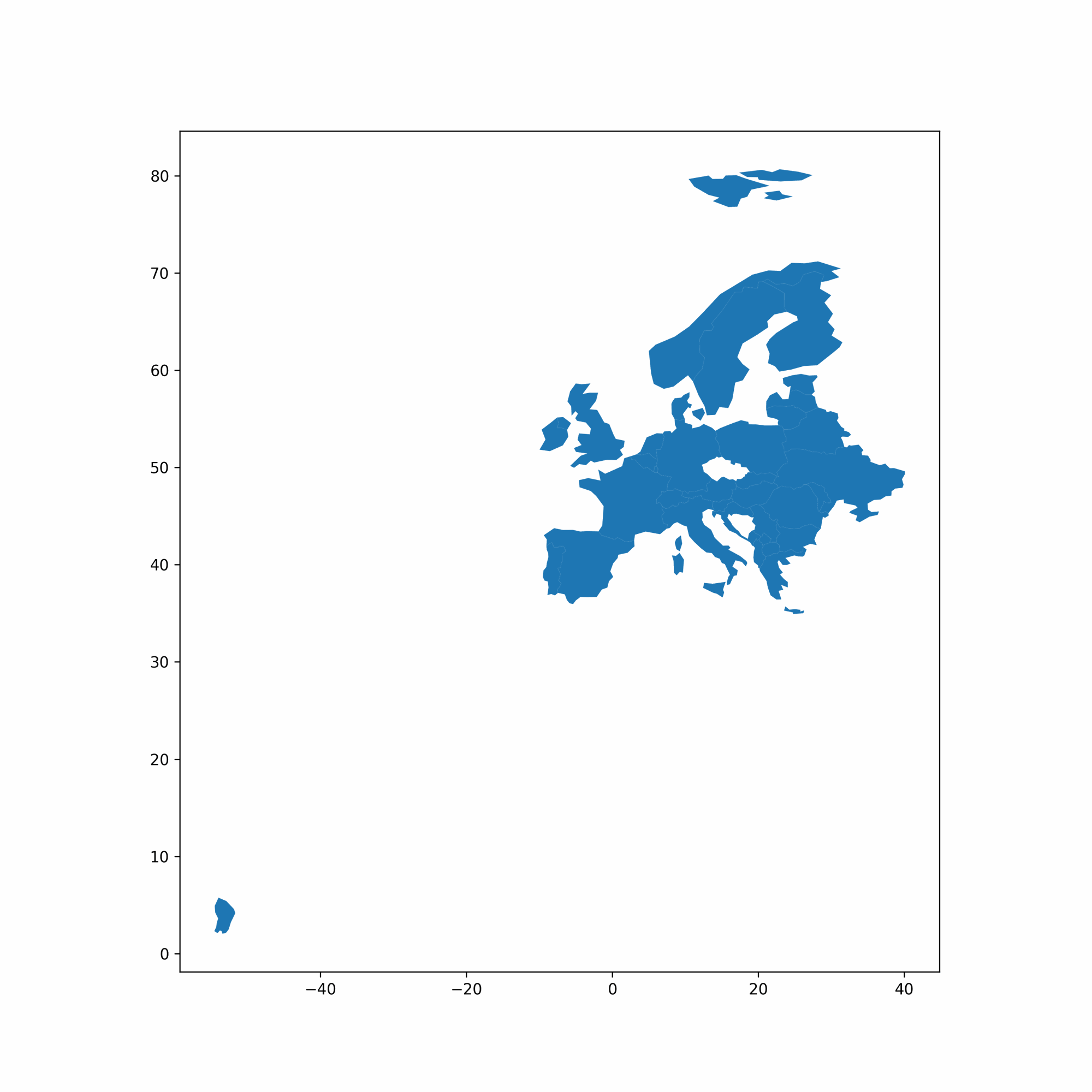
Thanks to the geopandas library, we can easily add a background map to our plot by simply calling the plot() function on our geo dataframe.
With just a few lines of code, we can create a synthetic map that displays a European map.
# initialize the figure
fig, ax = plt.subplots(figsize=(10, 10), dpi=300)

# create the plot
data.plot(ax=ax)
plt.show()
Custom axis
The next step is to adjust the plot's ranges (latitude and longitude) using the set_xlim() and set_ylim() functions on the axis object.
We also remove the spines around the map since they are not particularly useful in this context.
# initialize the figure
fig, ax = plt.subplots(figsize=(10, 10), dpi=300)

# create the plot
data.plot(ax=ax)

# custom axis
ax.set_xlim(-11, 41)
ax.set_ylim(32, 73)
ax.set_axis_off()

plt.show()
Choropleth map
A choropleth map is distinct from a background map because it employs color gradients to depict data, with each country shaded according to its data value.
We initiate by loading a colormap via the load_cmap() function from the pypalettes library, subsequently integrating this colormap into the plot by including cmap=cmap in the plot() function.
To enhance readability, we also define the edgecolor and linewidth of the countries.
# load colormap
cmap = load_cmap("BrwnYl", cmap_type="continuous")

# initialize the figure
fig, ax = plt.subplots(figsize=(10, 10), dpi=300)

# create the plot
data.plot(ax=ax, column="Total", cmap=cmap, edgecolor="black", linewidth=0.5)

# custom axis
ax.set_xlim(-11, 41)
ax.set_ylim(32, 73)
ax.set_axis_off()

plt.show()
Centroids and annotations
The easiest way to find the center of each country is to use the centroid attribute of the geometry column in the geo dataframe. These coordinates can then be used to add annotations to the map.
Since the default font isn't very attractive, we load two other fonts: one for the title and one for the annotations. We can then use the ax_text() function from the highlight_text library to add annotations to the map, and pyfonts to load the fonts from Github.
Just before adding the annotations, we define an adjustment dictionary to help us improve the approximate position of the annotations. This is necessary because centroids aren't always ideally positioned for annotations, especially in countries with outlying islands.
adjustments = {
    "France": (10, 3),
    "Italy": (-2.4, 2.5),
    "Finland": (0, -2),
    "Belarus": (0, -0.4),
    "Ireland": (0, -1),
    "Germany": (-0.2, 0),
    "Poland": (0, 0.2),
    "Sweden": (-1.2, -2.8),
    "United Kingdom": (1, -1.5),
    "Norway": (-4, -5.5),
}

# Example
print(adjustments["France"])
(10, 3)
# load colormap and other colors
cmap = load_cmap("BrwnYl", cmap_type="continuous")
background_color = "white"
text_color = "black"

# load the fonts
font = load_google_font("Bebas Neue")
other_font = load_google_font("Fira Sans", weight="light")
other_bold_font = load_google_font("Fira Sans", weight="medium")

# initialize the figure
fig, ax = plt.subplots(figsize=(10, 10), dpi=300)
fig.set_facecolor(background_color)
ax.set_facecolor(background_color)

# create the plot
data.plot(ax=ax, column="Total", cmap=cmap, edgecolor="black", linewidth=0.5)

# custom axis
ax.set_xlim(-11, 41)
ax.set_ylim(32, 73)
ax.set_axis_off()

# compute the centroid of each country
data_projected = data.to_crs(epsg=3035)
data_projected["centroid"] = data_projected.geometry.centroid
data["centroid"] = data_projected["centroid"].to_crs(data.crs)

# define which countries to annotate
countries_to_annotate = [
    "France",
    "Italy",
    "Romania",
    "Poland",
    "Finland",
    "Ukraine",
    "Spain",
    "Germany",
    "Sweden",
    "United Kingdom",
    "Belarus",
    "Norway",
]

# annotate each country
for country in countries_to_annotate:
    centroid = data.loc[data["name"] == country, "centroid"].values[0]
    x, y = centroid.coords[0]
    try:
        x += adjustments[country][0]
        y += adjustments[country][1]
    except KeyError:
        pass
    rate = data.loc[data["name"] == country, "Total"].values[0]
    if country == "United Kingdom":
        country = "UK"
    if rate > 7:
        color_text = "white"
    else:
        color_text = text_color  # 'black'
    ax_text(
        x=x,
        y=y,
        s=f"<{country.upper()}>: {rate:.2f}",
        fontsize=9,
        font=other_font,
        color=color_text,
        ha="center",
        va="center",
        ax=ax,
        highlight_textprops=[{"font": other_bold_font}],
    )

plt.show()
Add title and Luxembourg
Since Luxembourg is a small country, we annotate it outside of the map and use an arrow to explicitly show its position. We use the ax_text() function from the highlight_text library to add the annotation.
The arrow is added using the drawarrow library and its fig_arrow function.
To ensure the title is perfectly aligned with the source below, simply specify ha='center' in the ax_text() function. This guarantees that, regardless of the title's size, it will always be centered.
In other words, by using the same x value for both the title and the source, and setting ha='center', the title will always be centered with the source.
adjustments = {
    "France": (10, 3),
    "Italy": (-2.4, 2.5),
    "Finland": (0, -2),
    "Belarus": (0, -0.4),
    "Ireland": (0, -1),
    "Germany": (-0.2, 0),
    "Poland": (0, 0.2),
    "Sweden": (-1.2, -2.8),
    "United Kingdom": (1, -1.5),
    "Norway": (-4, -5.5),
}

# load colormap and other colors
cmap = load_cmap("BrwnYl", cmap_type="continuous")
background_color = "white"
text_color = "black"

# load the fonts
font = load_google_font("Bebas Neue")
other_font = load_google_font("Fira Sans", weight="light")
other_bold_font = load_google_font("Fira Sans", weight="medium")

# arrow properties
arrow_props = dict(width=0.5, head_width=4, head_length=8, color="black")

# initialize the figure
fig, ax = plt.subplots(figsize=(10, 10), dpi=300)
fig.set_facecolor(background_color)
ax.set_facecolor(background_color)

# create the plot
data.plot(ax=ax, column="Total", cmap=cmap, edgecolor="black", linewidth=0.5)

# custom axis
ax.set_xlim(-11, 41)
ax.set_ylim(32, 73)
ax.set_axis_off()

# compute the centroid of each country
data_projected = data.to_crs(epsg=3035)
data_projected["centroid"] = data_projected.geometry.centroid
data["centroid"] = data_projected["centroid"].to_crs(data.crs)

# define which countries to annotate
countries_to_annotate = [
    "France",
    "Italy",
    "Romania",
    "Poland",
    "Finland",
    "Ukraine",
    "Spain",
    "Germany",
    "Sweden",
    "United Kingdom",
    "Belarus",
    "Norway",
]

# annotate each country
for country in countries_to_annotate:
    centroid = data.loc[data["name"] == country, "centroid"].values[0]
    x, y = centroid.coords[0]
    try:
        x += adjustments[country][0]
        y += adjustments[country][1]
    except KeyError:
        pass
    rate = data.loc[data["name"] == country, "Total"].values[0]
    if country == "United Kingdom":
        country = "UK"
    if rate > 7:
        color_text = "white"
    else:
        color_text = text_color  # 'black'
    ax_text(
        x=x,
        y=y,
        s=f"<{country.upper()}>: {rate:.2f}",
        fontsize=9,
        font=other_font,
        color=color_text,
        ha="center",
        va="center",
        ax=ax,
        highlight_textprops=[{"font": other_bold_font}],
    )

# title
fig_text(
    s="CO2 emissions per capita in Europe (2021)",
    x=0.5,
    y=0.14,
    color=text_color,
    fontsize=25,
    font=font,
    ha="center",
    va="top",
    ax=ax,
)

# subtitle
fig_text(
    s="<Unit>: metric tons | <Data>: zenodo.org | <Viz>: barbierjoseph.com",
    x=0.5,
    y=0.1,
    color=text_color,
    fontsize=14,
    font=other_font,
    ha="center",
    va="top",
    ax=ax,
    highlight_textprops=[
        {"font": other_bold_font},
        {"font": other_bold_font},
        {"font": other_bold_font},
    ],
)

# arrows for the Luxembourg
luxembourg_values = data.loc[data["name"] == "Luxembourg", "Total"].values[0]
fig_arrow(
    tail_position=(0.32, 0.7), head_position=(0.375, 0.45), radius=0.3, **arrow_props
)
fig_text(
    s=f"<LUXEMBOURG>: {luxembourg_values:.2f}",
    x=0.32,
    y=0.71,
    highlight_textprops=[{"font": other_bold_font}],
    color=text_color,
    fontsize=9,
    font=other_font,
    ha="center",
    va="center",
    fig=fig,
)

plt.show()
Final Chart with Legend
Creating the legend for this chart involves some straightforward steps:
- Define
value_rangesas a list storing the legend values:[1, 3, 5, 7, 9, 11, 13, 15]. - Define
labelsas a list storing the legend labels:['0-2 t', '2-4 t', '4-6 t', '6-8 t', '8-10 t', '10-12 t', '12+ t'].
Note that value_ranges contains one more element than the labels list due to the method used for color calculation.
# load the colormap
cmap = load_cmap("BrwnYl", cmap_type="continuous")
background_color = "white"
text_color = "black"

value_ranges = [1, 3, 5, 7, 9, 11, 13, 15]
labels = ["0-2 t", "2-4 t", "4-6 t", "6-8 t", "8-10 t", "10-12 t", "12+ t"]

# load the font
font = load_google_font("Bebas Neue")
other_font = load_google_font("Fira Sans", weight="light")
other_bold_font = load_google_font("Fira Sans", weight="medium")

# arrow properties
arrow_props = dict(width=0.5, head_width=4, head_length=8, color="black")

# initialize the figure
fig, ax = plt.subplots(figsize=(10, 10), dpi=300)
fig.set_facecolor(background_color)

# create the plot
data.plot(ax=ax, column="Total", cmap=cmap, edgecolor="black", linewidth=0.5)

# custom axis
ax.set_xlim(-11, 41)
ax.set_ylim(32, 73)
ax.set_axis_off()

# define range and values for the legend
value_ranges = [1, 3, 5, 7, 9, 11, 13, 15]
labels = ["0-2 t", "2-4 t", "4-6 t", "6-8 t", "8-10 t", "10-12 t", "12+ t"]

# parameters of the legend
rectangle_width = 2
rectangle_height = 1.5
legend_x = 35
legend_y_start = 65
legend_y_step = 1.5

# create the legend
for i in range(len(labels)):
    value = (
        (value_ranges[i] + value_ranges[i + 1]) / 2 / value_ranges[-1]
    )  # Normalize the value to [0, 1]
    color = cmap(value)
    ax.add_patch(
        plt.Rectangle(
            (legend_x, legend_y_start - i * legend_y_step),
            rectangle_width,
            rectangle_height,
            color=color,
            ec="black",
            lw=0.6,
        )
    )
    ax.text(
        legend_x + 2.5,
        legend_y_start - i * legend_y_step + 0.7,
        labels[i],
        fontsize=12,
        fontproperties=other_font,
        color=text_color,
        va="center",
    )

# compute centroids and display the total
adjustments = {
    "France": (10, 3),
    "Italy": (-2.4, 2.5),
    "Finland": (0, -2),
    "Belarus": (0, -0.4),
    "Ireland": (0, -1),
    "Germany": (-0.2, 0),
    "Poland": (0, 0.2),
    "Sweden": (-1.2, -2.8),
    "United Kingdom": (1, -1.5),
    "Norway": (-4, -5.5),
}
data_projected = data.to_crs(epsg=3035)
data_projected["centroid"] = data_projected.geometry.centroid
data["centroid"] = data_projected["centroid"].to_crs(data.crs)
countries_to_annotate = data["name"].tolist()
countries_to_annotate = [
    "France",
    "Italy",
    "Romania",
    "Poland",
    "Finland",
    "Ukraine",
    "Spain",
    "Germany",
    "Sweden",
    "United Kingdom",
    "Belarus",
    "Norway",
]
for country in countries_to_annotate:
    centroid = data.loc[data["name"] == country, "centroid"].values[0]
    x, y = centroid.coords[0]
    try:
        x += adjustments[country][0]
        y += adjustments[country][1]
    except KeyError:
        pass
    rate = data.loc[data["name"] == country, "Total"].values[0]
    if country == "United Kingdom":
        country = "UK"
    if rate > 7:
        color_text = "white"
    else:
        color_text = text_color
    ax_text(
        x=x,
        y=y,
        s=f"<{country.upper()}>: {rate:.2f}",
        fontsize=9,
        font=other_font,
        color=color_text,
        ha="center",
        va="center",
        ax=ax,
        highlight_textprops=[{"font": other_bold_font}],
    )

# title
fig_text(
    s="CO2 emissions per capita in Europe (2021)",
    x=0.5,
    y=0.14,
    color=text_color,
    fontsize=25,
    font=font,
    ha="center",
    va="top",
    ax=ax,
)

# subtitle
fig_text(
    s="<Unit>: metric tons | <Data>: zenodo.org | <Viz>: barbierjoseph.com",
    x=0.5,
    y=0.1,
    color=text_color,
    fontsize=14,
    font=other_font,
    ha="center",
    va="top",
    ax=ax,
    highlight_textprops=[
        {"font": other_bold_font},
        {"font": other_bold_font},
        {"font": other_bold_font},
    ],
)

# arrows for the Luxembourg
luxembourg_values = data.loc[data["name"] == "Luxembourg", "Total"].values[0]
fig_arrow(
    tail_position=(0.32, 0.7), head_position=(0.375, 0.45), radius=0.3, **arrow_props
)
fig_text(
    s=f"<LUXEMBOURG>: {luxembourg_values:.2f}",
    x=0.32,
    y=0.71,
    highlight_textprops=[{"font": other_bold_font}],
    color=text_color,
    fontsize=9,
    font=other_font,
    ha="center",
    va="center",
    fig=fig,
)

# display the plot
plt.savefig("../../static/graph/web-map-with-custom-legend.png", dpi=300)
plt.show()
Going further
You might be interested in:
- multiple choropleth maps on the same figure
- how to create great legends for categorical data
- how to create a tile map with matplotlib